Only to be attempted by the physically fit and adventurous!
A place of outstanding natural beauty with wonderful river pools and spectacular views. For the more adventurous, there is no better way to spend a day out.
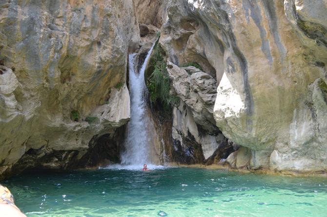
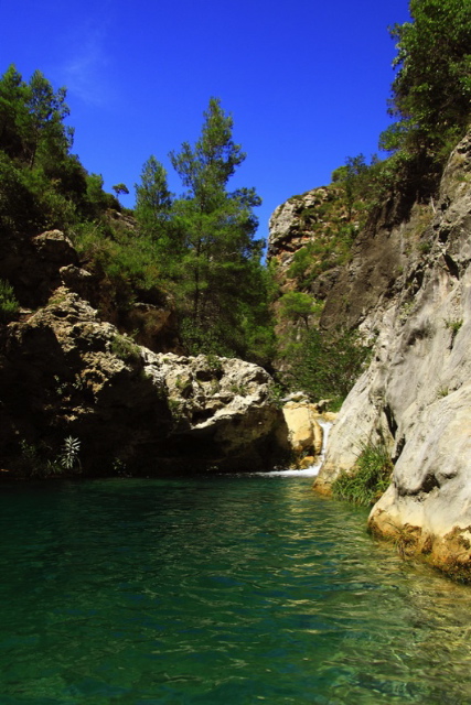
Junta de los Rios translates as ‘the joining of the rivers’. The rivers Rio Verde and Rio Negro meet to form waterfalls and crystal, clear pools in which you can bathe. Until recently, the river was relatively unexplored and was used only for people practising ‘adrenaline’ sports, mainly climbing and barranquismo (canyoning) with specialist groups taking people on guided tours. Over the last few years the area has opened up somewhat, although it is still not on the regular tourist route.
Getting there
From Almunecar, take the A-4050 northwards, the Carretera Suspiro del Moro (or La Cabra, as it is known locally) towards Granada city. The route passes through some beautiful countryside and is at the heart of the ‘tropical valley.’ Passing through kilometres of subtropical fruits and vegetation. The villages are renowned for the exportation of mangoes, avocados, pears and the distinctive pink fruit of the nispero, an Andalusian delicacy.
Passing through the villages of Jete and then Otivar, the entrance gate to the river is on the left hand side, just beyond the turning for the Palacete de Cazulas (approximately 2kms from Otivar). Keep your eyes open as it is very easy to miss, there is a small gateway with a hut behind. Inside is a person who registers all cars/people and you pay an entrance fee. The access road is private and the fee helps to keep it ‘maintained’.
The road leading to the ‘Junta’ is approximately 6kms and track. It can be pretty rough in places, particularly with a heavily loaded car. Follow the road down until reaching the mouth of the gorge. Depending on the type of vehicle (and your nerves) you can park here or carry on.
Although if not in a good 4x4, its advisable to park here and walk.
Following the river on your right, you keep walking and almost immediately the river opens up with plenty of pools for bathing and small waterfalls. It takes approximately one hour to get to an old disused dam/farm, from here you need to bear right and start crossing the rivers several times and eventually make your way up to the higher/deeper pools.
Of note
Please note, a responsible level of fitness is required. The ground is not level, there are several bridges to cross and the path is very steep in places. A fter several flash floods, the valley has been severely eroded (particularly around the dam area), adding to the difficultly.
Heat and water are two things to take into consideration. Check the weather forecasts, do not go anywhere near this valley if rain is predicted anywhere in the area. Even the remotest chance of rain should be reason enough to change plans.
Hiking in this valley can be very hot going in the summer months with temperatures sometimes well over 40C in the shade. You have water to cool off in and drink...but its still something to bear in mind, particularly if travelling with children.
There's a fantastic hike from the lower river pools up the valley and onto some larger waterfalls. You need to be fit and willing to cross the river numerous times. Cross over the hanging bridge and keep following the path upwards into the mountains, the path eventually drops back down to the river, crossing it several times. After 5kms or so, you'll come to a large hanging bridge.
Cross over and bear rightwards and upwards. You quickly see a large waterfall. You'll know when you are there. To keep going any further up the river you would need specialist equipment and a guide.
There are several paths that lead leftwards and up into the mountains. I don't recommend taking them if you don't know the area. It’s a long and a very steep hike back up to the main road and civilisation. If you do venture away from the river, make sure you take lots of water.
Another important point to bear in mind is there is no mobile phone coverage in many parts of the valley.
Entrance to Junta de los Rios
The office/cabin is manned from 10.00 to 19.00 on Tuesday to Sunday, closed on Mondays. The key can be obtained from the El Capricchio Bar in Otivar during the winter.
During the summer months, June onwards there is someone on the gate to let you in. At the time of writing, the entrance fee was €5 per person and a further €5 for the car. Children go for free. Phone 680493629 or 680493907 for further information (and to check on conditions!).

At the risk of sounding cliché, the Embalse de Los Bermejales is another one of those spots in Andalucía that really is a hidden gem. Far removed from the usual tourist circuit, you couldn't hope for a more peaceful or beautiful place to spend a holiday and/or weekend.
It’s hard to believe that you are less than an hour’s drive from the Costa Tropical, forty minutes from Granada and with some of the region’s prettiest villages right on your doorstep. The area is slowly opening up to tourism.
Some lucky foreigners have chosen to live there, attracted by the lower property prices and the more traditional lifestyle. But it remains predominantly Spanish.
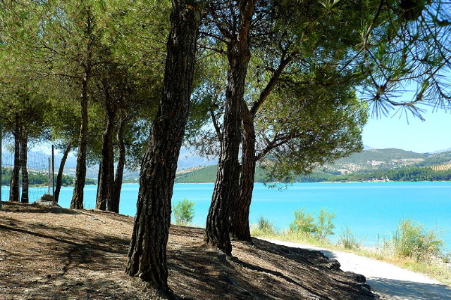
The lake is very close to the village of Alhama de Granada, as you drop down from the mountains you start to catch glimpses of the lake through the pine trees.
What is Bermejales?
Bermejales lake is a man-made reservoir. A big one. It covers 562 Ha and has a circumference of 28km.
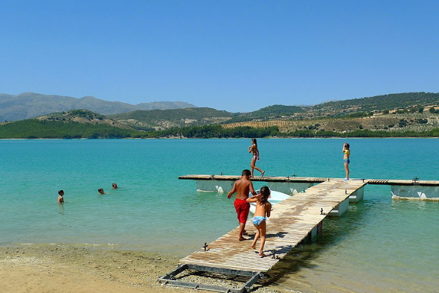
The water quality is amazing. Very clean and warm. It is almost like swimming in bath water. On a calm day, it is a very safe place for children to swim, there are no waves or currents. It is also filled with fish – mainly barbel and carp. Lots of fish! Throw in a piece of bread and all hell breaks loose. Children love it.
Things to see and do
- Swimming, canoeing, sailing – anything that hasn't got a motor is permitted.
- Mountain biking – there are some great trails in and around Bermejales, including one that does the circumference of the lake.
- Hiking - the area has some great hiking. The Rio Cebollón one is a spectacular route.
- A visit to the villages of Arenas del Rey, Alhama de Granada, Jatar and Jayena is recommended.
- The village of Jayena is famous for its aromatic plants, it was the last place where “Materos,” (collectors of wild aromatic plants) lived and worked. A tradition they kept alive until 2002.
- Off the beaten track – the Resinera river pools near the village of Fornes.
- Just next to the campsite (see below), there is also one of the most ‘chilled out,’ beach huts/cafés in Spain. People sit back, listening to music and watch the sunset over the lake. You can't go wrong really.
How to get there
The Embalse is big, there are plenty of quiet corners to seek out. We usually go to the ‘beach’ area next to the campsite. The swimming is very safe. They have a floating pontoon, that children will love jumping off and it offers all kinds of activities – you can rent canoes, pedalos and occasionally catamarans there.
If coming from the Alhama de Granada direction, you should be on the A-402. After a couple of kilometres you'll start to see signs for the “Embalse/Pantano de Los Bermejales”, follow the signs taking a right onto A-338.
This road takes you straight to the lake. For the campsite area follow signs for the “Poblado del Embalse” (leftwards), passing through the ‘village’ and you’ll eventually see the campsite. The beach area is just in front.